Publications
On the way to the next level of GeoAI.
2026
-
 Geo2Vec: Shape- and Distance-Aware Neural Representation of Geospatial EntitiesChen Chu, and Cyrus ShahabiAAAI 2026 (Oral), Jan 2026
Spatial representation learning is essential for GeoAI applications such as urban analytics, enabling the encoding of shapes, locations, and spatial relationships (topological and distance-based) of geo-entities like points, polylines, and polygons. Existing methods either target a single geo-entity type or, like Poly2Vec, decompose entities into simpler components to enable Fourier transformation, introducing high computational cost. Moreover, since the transformed space lacks geometric alignment, these methods rely on uniform, non-adaptive sampling, which blurs fine-grained features like edges and boundaries. To address these limitations, we introduce Geo2Vec, a novel method inspired by signed distance fields (SDF) that operates directly in the original space. Geo2Vec adaptively samples points and encodes their signed distances (positive outside, negative inside), capturing geometry without decomposition. A neural network trained to approximate the SDF produces compact, geometry-aware, and unified representations for all geo-entity types. Additionally, we propose a rotation-invariant positional encoding to model high-frequency spatial variations and construct a structured and robust embedding space for downstream GeoAI models. Empirical results show that Geo2Vec consistently outperforms existing methods in representing shape and location, capturing topological and distance relationships, and achieving greater efficiency in real-world GeoAI applications.

2025
-
 One Model, Many Cities: A Transferable Social Relationship Inference Framework for Human Mobility DataChen Chu, Cyrus Shahabi, Emmanuel Tung, and 1 more authorACM SIGSPATIAL 2025 (Best Paper Runner-up), Jan 2025
Inferring social relationships from mobility data is crucial for many applications because it reflects real-world connections among people. However, large-scale trajectory datasets with ground-truth social ties are exceedingly scarce, making it difficult to train deep models for relationship inference. To address this gap, we propose a transferable social relationship inference framework that can be trained on one high-quality, labeled dataset and then generalized to new datasets, even from different cities.\{Our framework rests on the key insight that social bonds depend largely on the frequency of individual meetings and the popularity of those meeting locations, both of which can be inferred statistically from raw trajectory data, irrespective of the underlying geographic semantics. It comprises two main modules: 1) Universal Social Relationship Classifier (USRC): A model trained to infer social relationships from trajectory data, and 2) Spatial Embedding Transfer (SET): A location embedding alignment technique that adapts new datasets to the pre-trained USRC model.\{By aligning location embeddings, SET module enables the pre-trained USRC to interpret previously unseen datasets without extra supervision. Experiments on five public datasets demonstrate that our method achieves state-of-the-art performance in zero-shot social relationship inference, surpassing other unsupervised, and in some cases, even supervised, approaches. Additionally, the SET module significantly improves location embedding alignment, outperforming existing baseline methods.

2024
-
 Simulating Human Mobility with a Trajectory Generation Framework Based on Diffusion ModelChen Chu, Zhang Hengcai, and Lu FengInternational Journal of Geographical Information Science, Aug 2024
Most of the current mobility modeling methods are specially designed to solve one specific task, which leads to questions regarding generalizability. Inspired by the bloom of foundation models, we proposed a generalized Trajectory Generation framework based on Diffusion Model (TrajGDM) to capture the universal mobility pattern in a trajectory dataset by learning the trajectory-generation process. The process is modeled as a step-by-step uncertainty reducing process, which estimates uncertainty with a trajectory generator network. We compared the proposed trajectory generation method with five benchmarks on two public trajectory datasets. The result showed that the similarity between generated and real trajectory movements measured by Jensen-Shannon Divergence improved by at least 50.3% on both datasets. Moreover, we applied zero-shot inferences to two basic trajectory tasks: trajectory prediction and trajectory reconstruction. The zero-shot prediction accuracy of our model is up to 23.4% higher than the benchmark, and the reconstruction accuracy improves by a maximum of 25.6%. The universal mobility pattern that suits for solving multiple trajectory tasks is verified by the zero-shot multi-tasks inferring ability of our model. At last, the study gave insights into the generation of trajectories by exploring the way the model maps trajectory’s representation in the latent space into reality.

2023
-
 TrajGDM: A New Trajectory Foundation Model for Simulating Human MobilityChen Chu, Zhang Hengcai, and Lu FengACM SIGSPATIAL 2023, Nov 2023
Capturing the universal movement pattern and simulating human mobility is one of the most important trajectory data-mining tasks. Most of the current mobility modeling methods are specially designed to solve a specific task, which leads to questions regarding generalizability. Aiming to construct a general trajectory foundation model to overcome this weakness, we proposed a generative Trajectory Generation framework based on Diffusion Model (TrajGDM) to capture the universal mobility pattern and simulate human mobility. It is capable of solving multiple trajectory tasks through learning the generation of the trajectory. The generation process of a trajectory is modeled as a step-by-step uncertainty reducing process. A trajectory generator network is proposed to estimate the uncertainty in each step, and a trajectory diffusion and generation process is defined to train the model to simulate the real dataset. Finally, we compared the proposed method with 5 strong baselines on 2 public trajectory datasets: T-Drive and Geo-life. By comparing 5 different evaluation metrics, the result showed that the similarity between generated and real trajectories’ movements measured by Jensen-Shannon Divergence improved by at least 50.3% in both datasets. It also addresses the problem of generating diverse trajectories, which is ignored by most previous models. Then, we conducted zero-shot experiments on two trajectory tasks, trajectory prediction and reconstruction. In trajectory prediction, the accuracy of TrajGDM’s zero-shot inference is up to 23.4% higher than that of the benchmark method, and the reconstruction accuracy increased by a maximum of 25.6%.
-
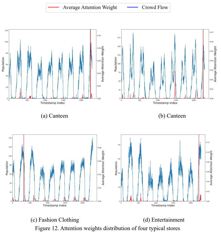 DeepIndoorCrowd: Predicting Crowd Flow in Indoor Shopping Malls with an Interpretable Transformer NetworkChen Chu, Zhang Hengcai, Wang Peixiao, and 1 more authorTransactions in GIS, Jul 2023
Accurate and interpretable prediction of crowd flow would benefit business management and public security. The existing studies are challenged to adapt to the indoor environment due to its complex and dynamic spatial interaction patterns. In this study, we propose a crowd flow predicting method for indoor shopping malls, which simultaneously features temporal variables and semantic factors to suit the shopping mall environment. A deep learning model named DeepIndoorCrowd is presented. The model aims at capturing temporal dependencies and the semantic pattern in crowd flow to generate an accurate multi-horizon prediction. With a multi-term temporal dependencies capturing structure, the model is effective in learning both daily and weekly patterns of the indoor crowd flow in a shopping mall and is able to provide the temporal interpretation of the prediction result. Moreover, a semantic-temporal fusion module is introduced to utilize the semantic information of stores in prediction, which was proved to be effective in enhancing the model’s ability to learn temporal patterns. Experiments were conducted on a real-world dataset to verify the proposed predicting approach. The ablation study demonstrates that the DeepIndoorCrowd can effectively improve the efficiency and accuracy of the prediction, and the accuracy increment is up to 18.7%. In addition, some interesting indoor crowd flow patterns were discovered by analyzing model’s interpretation to the prediction result. The proposed prediction method provides an intuitive way of modeling indoor crowd flow, and the experiment’s outcome can help indoor managers better understand stores’ flow traffic.
-
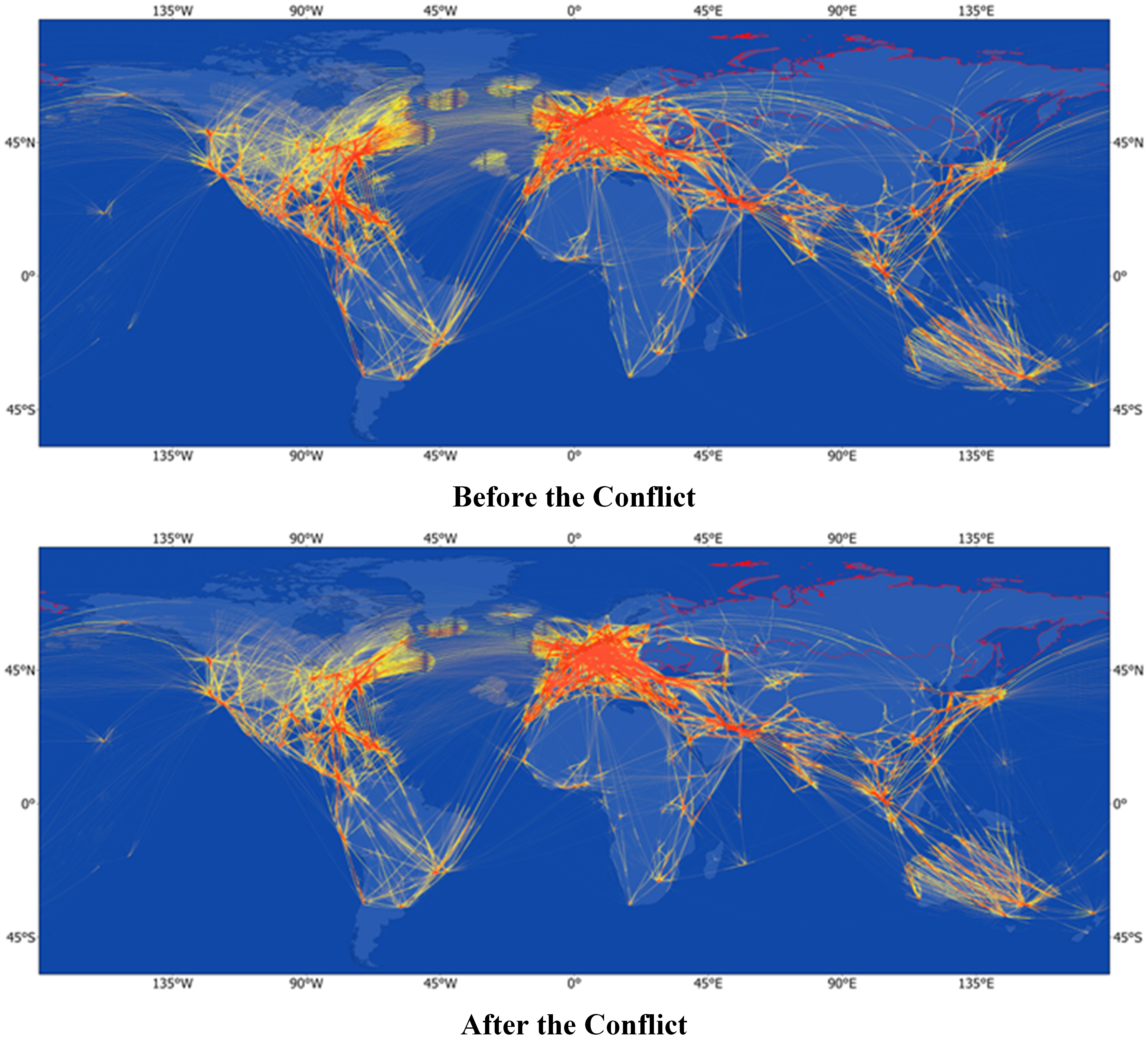 Assessing Impacts of the Russia-Ukraine Conflict on Global Air Transportation: from the View of Mass Flight TrajectoriesChen Chu, Zhang Hengcai, Zhang Jiayin, and 1 more authorJournal of Air Transport Management, Dec 2023
Air transportation has been severely affected by the Russia-Ukraine conflict. The closure of involved Russian and Ukrainian airspace made a great number of flights suffer from a dramatic transportation cost increase. Accurately estimating the conflict’s impact can help us better comprehend the susceptibility of international airlines and optimize flying routes for global airlines. In this study, we quantitatively analyzed the impact the conflict has brought on global air transportation. The detour of airlines and the variation of flights caused by the conflict were assessed from the view of mass flight trajectories. A flight cost increment index is proposed to reveal the extra costs of involved countries. The impacts on each involved country are further analyzed and the airlines influenced the most are identified. The results show that the flight cost of 6.23% of global international flights significantly increased by 13.32% due to the conflict. Furthermore, as one of the few researches that analyze the impact of regional events on global air transportation, the result of the study reveals the vulnerability of international airlines and provides instruction for flying route optimization.
-
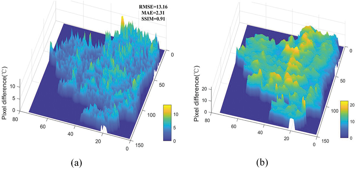 Detection of geothermal potential based on land surface temperature derived from remotely sensed and in-situ dataFei Zhao, Zhiyan Peng, Qian Jiangkang, and 1 more authorGeo-spatial Information Science, Dec 2023


2022
-
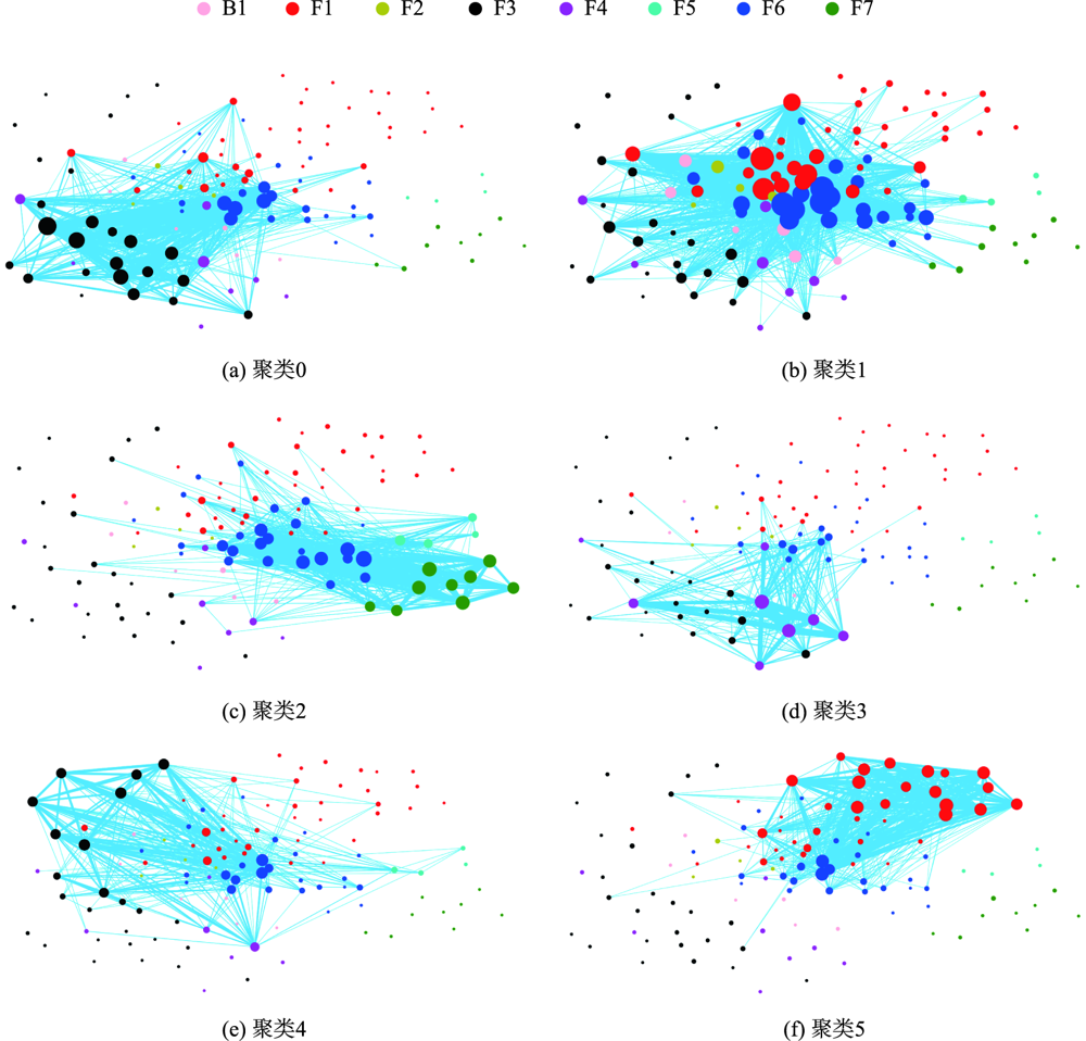 Inferring Consumption Behavior of Customers in Shopping Malls from Indoor TrajectoriesChen Chu, Zhang Hengcai, and Lu FengJournal of Geo-Information Science, Dec 2022
How to obtain the consumption behavior of massive customers in large indoor shopping malls has always been a difficult problem in behavioral geography. However, with the explosive growth of indoor trajectory data in recent years, there’s a great opportunity to solve this problem. Meanwhile, the lack of semantic information and poor data quality of indoor trajectory still pose challenges to the inference of consumer behavior. This study proposes a framework for customers’ consumption behavior inference in shopping malls without collecting private personal consumption records. This framework integrates the Web text information of stores with movement features extracted from personal and historical customer trajectories. The semantic attributes of indoor stores are enhanced by introducing the crawled network text data of indoor stores, so as to realize the transformation from customer geometric trajectory to semantic trajectory. Specifically, the framework offers a method to model the customers’ consumption feature from three aspects, including the raw trajectory’s movement feature, semantic feature, and movement embedding feature. By employing the representation learning algorithm in extraction of customers’ movement embedding feature, the framework can learn the movement pattern from the historical crowd trajectories and use the movement embedding feature to model movements of a single customer in a complex indoor environment automatically. Finally, the research realizes residents’ consuming behavior inference by clustering the concatenated multi-sources consuming features and analyzing the clusters with statistic values and visualization. Through the experimental analysis of a real-world indoor trajectory dataset generated from a large shopping mall with 7045 customers, the inference result proves that the framework can effectively extract the spatial-temporal movement and consumption pattern of residents. Comparing with the classic feature extraction methods and typical clustering methods, the framework we propose achieves an improvement for up to 69.8% in the Silhouette Coefficient. This improvement illustrates that the customers’ consumption behavior inferring framework we propose can identify the customers with different consuming behaviors more effectively and cluster customers’ feature with high dimension more precisely. Through the analysis of indoor customer clusters’ movement pattern, the research finds out that the moving behavior of all shopping mall customers are affected directly and prominently by the design of indoor environment e.g., the distribution of functional zones, location of escalators, etc. Besides, the research also finds out that customers have strong preference to consume in the identical floor. The framework we proposed can identify customer groups with different consumption levels and movement patterns and discover consuming patterns from massive shopping mall customers without knowing their personal information. The application of the framework in inferring customer behavior patterns could provide a support for relative researches in behavioral geography.
-
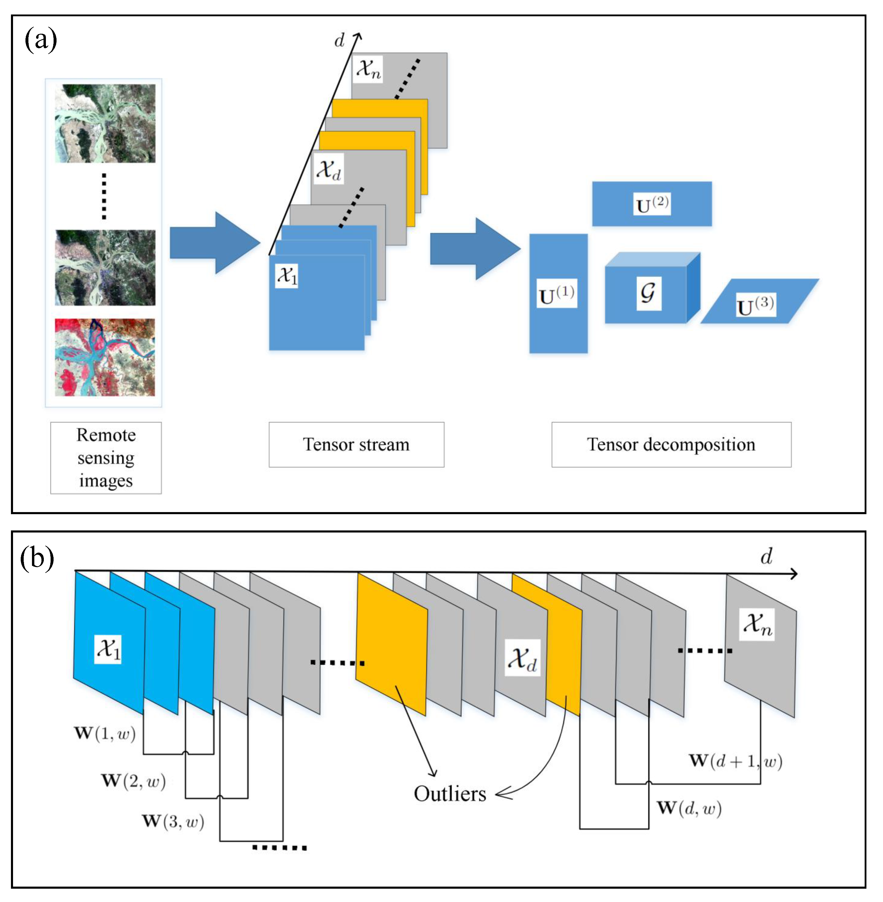 Outlier Reconstruction of NDVI for Vegetation-Cover Dynamic AnalysesZhengbao Sun, Lizhen Wang, Chen Chu, and 1 more authorApplied Sciences, Dec 2022
The normalized difference vegetation index (NDVI) contains important data for providing vegetation-cover information and supporting environmental analyses. However, understanding long-term vegetation cover dynamics remains challenging due to data outliers that are found in cloudy regions. In this article, we propose a sliding-window-based tensor stream analysis algorithm (SWTSA) for reconstructing outliers in NDVI from multitemporal optical remote-sensing images. First, we constructed a tensor stream of NDVI that was calculated from clear-sky optical remote-sensing images corresponding to seasons on the basis of the acquired date. Second, we conducted tensor decomposition and reconstruction by SWTSA. Landsat series remote-sensing images were used in experiments to demonstrate the applicability of the SWTSA. Experiments were carried out successfully on the basis of data from the estuary area of Salween River in Southeast Asia. Compared with random forest regression (RFR), SWTSA has higher accuracy and better reconstruction capabilities. Results show that SWTSA is reliable and suitable for reconstructing outliers of NDVI from multitemporal optical remote-sensing images.


2021
-
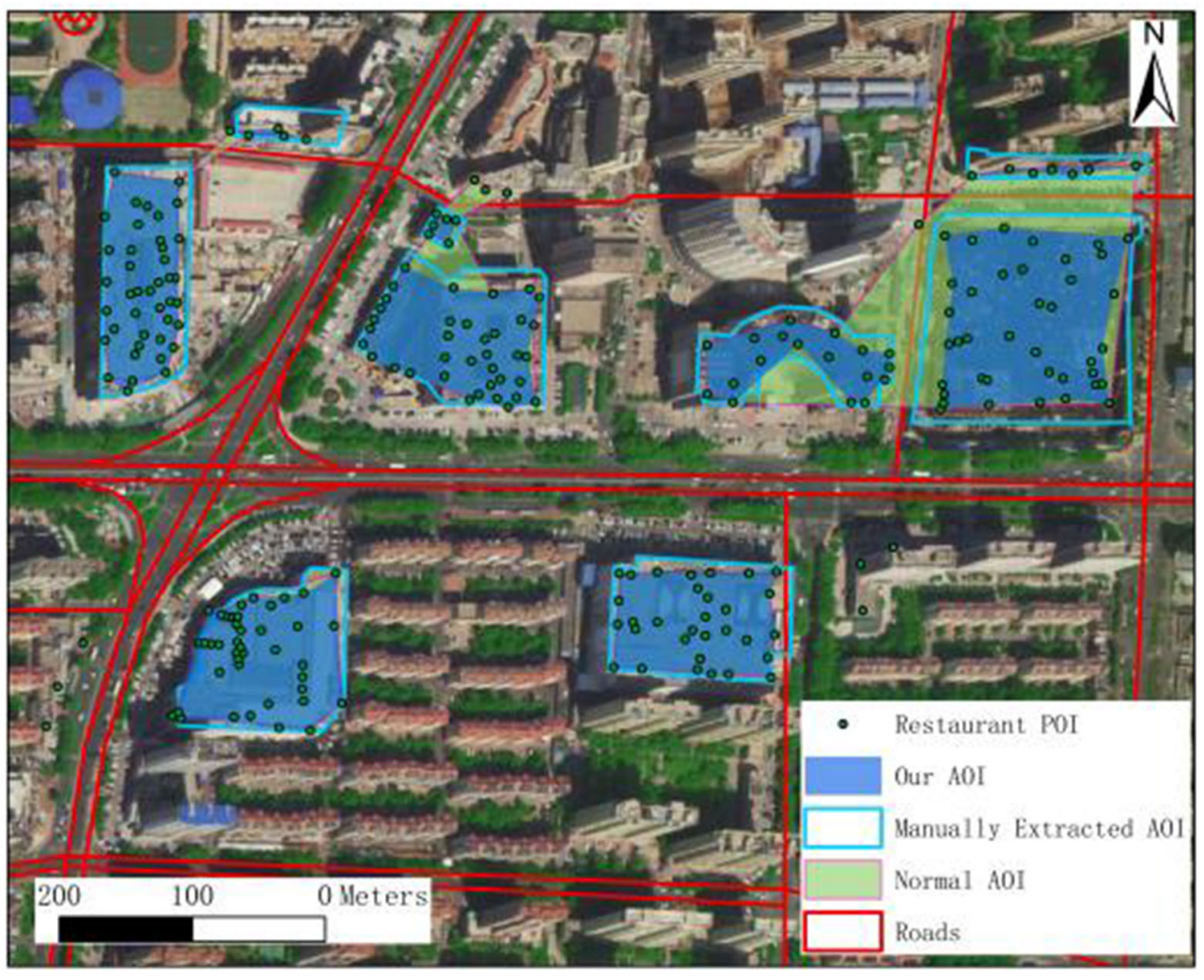 Assessing Light Pollution Using POI and Luojia1-01 Night-Time Imagery From a Quantitative Perspective at City ScaleFei Zhao(Supervisor), Chen Chu, Rui Liu, and 6 more authorsIEEE Journal of Selected Topics in Applied Earth Observations and Remote Sensing, Dec 2021
In previous studies using night-time light (NTL) image in analyzing light pollution, most of the researchers focused on national or regional scale analysis. While in this article we focus on the perception of light pollution’s influence to the environment of human settlement. We propose an analysis method mainly utilizing NTL images and a city’s point of interest (POI) data to assess the light pollution from the aspect of its impact on the environment of city residents. The method quickly provides light pollution analysis at a fine spatial scale. We also address the POI data in a novel aggregating algorithm to better construct the area of interest, which can conquer the limitation of spatial resolution of NTL data in some extent. By doing the assessment in two Chinese medium-size cities, light pollution sources, the pollution level for each residence are found and analyzed. Furthermore, several light pollution patterns are discovered and interpreted. The result of the experiment demonstrates our assessment method provides a fast way to analyze light pollution patterns and can show the detailed light pollution situation in a city.
-
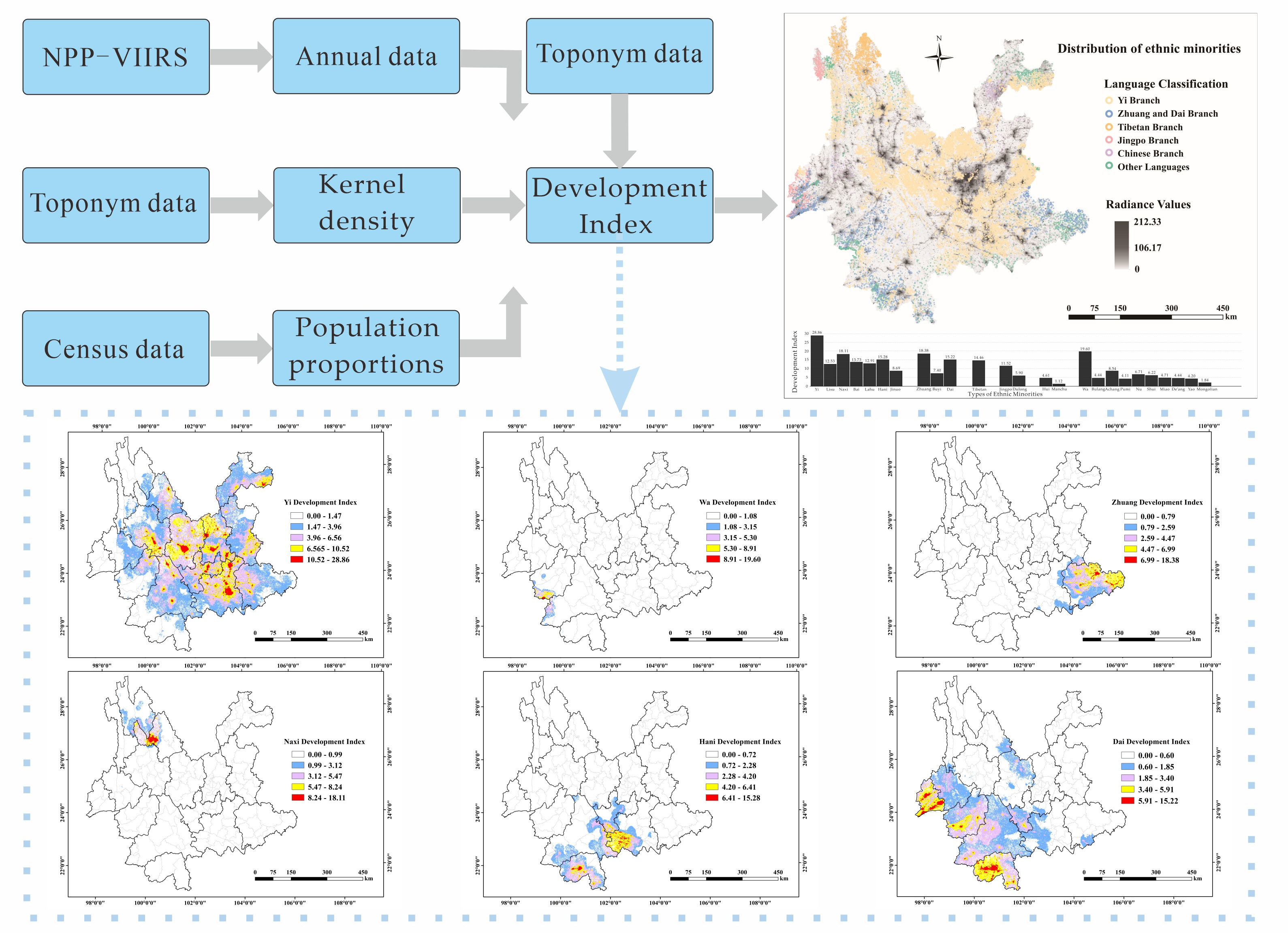 Night-Time Light Remote Sensing Mapping: Construction and Analysis of Ethnic Minority Development IndexFei Zhao, Lu Song, Zhiyan Peng, and 7 more authorsRemote Sensing, Dec 2021
Using toponym data, population data, and night-time light data, we visualized the development index of the Yi, Wa, Zhuang, Naxi, Hani, and Dai ethnic groups on ArcGIS as well as the distribution of 25 ethnic minorities in the study area. First, we extracted the toponym data of 25 ethnic minorities in the study area, combined with night-time light data and the population proportion data of each ethnic group, then we obtained the development index of each ethnic group in the study area. We compared the development indexes of the Yi, Wa, Zhuang, Naxi, Hani, and Dai ethnic groups with higher development indexes. The results show that the Yi nationality’s development index was the highest, reaching 28.86 (with two decimal places), and the Dai nationality’s development index was the lowest (15.22). The areas with the highest minority development index were concentrated in the core area of the minority development, and the size varied with the minority’s distance. According to the distribution of ethnic minorities, we found that the Yi ethnic group was distributed in almost the entire study area, while other ethnic minorities had obvious geographical distribution characteristics, and there were multiple ethnic minorities living together. This research is of great significance to the cultural protection of ethnic minorities, the development of ethnic minorities, and the remote sensing mapping of lights at night.

